VENDU
34 parts in 32 volumes, 12mo (160 x 90 mm). Almost uniformly bound (except for Letters VI, XXI, XXVII, XXVIII) in contemporary marbled calf, spine gilt with raised bands, red edges (skilfully restored).
1 in stock
Sabin, 40697 ; de Backer-Sommervogel, III, 1514 (under the name of the editor Le Gobien with only parts I à XXVI) – V, 35-36 (for the parts edited by Du Halde)- VI, 353-354 (for the volumes edited by Father Patouillet) ; Alden-Landis, 703/78) ; Cordier, Sinica, 927-930 ; Streeter collection, vol. IV, 2424 (only part V with the map by Kino on California, published in 1705) ; Hill, 1014 (only 2nd edition, 1780-1783) ; Löwendahl, p. XLV, number ‘b’ & 299 (7), 301 (8), 324 (3), 328 (11), 330-331 (1-2), 335 (13), 337 (14), 340 (15) 343 (6), 346 (16) 347 (5), 353 (17), 358 (18), 360 (19), 367 (9), 370 (20), 376 (10), 387 (21), 400 (22), 405 (23), 410 (24), 418 (12), 419 (25), 426 (26), 451 (27), 495 (28), 579-580 (31-32), 590-591 (33-34).
A fine copy of this extremely rare book, the sum of the knowledge of Jesuit travellers in the XVIIIth century. It is absolutely complete with all 34 volumes, most of them in first edition.
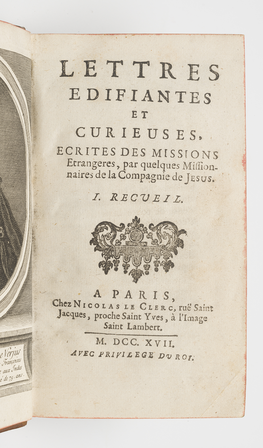
Volumes VIII, XII, and XIII-XXXIV in first edition; the others in re-issues. The Lettres édifiantes were a system of correspondence established by Ignatius of Loyola, founder of the Society of Jesus, in which missionaries gave news and details of their countries. Initially published individually, it was the Breton priest Le Gobien (1652-1708) who published them systematically from 1702 onwards.
This monumental series, begun under the direction of Charles le Gobien, was intended to provide a history of the Jesuit missions and news from China. Subsequently, accounts of many of the Jesuits’ missionary missives from all the regions where they were active were added, along with information on science, medicine, natural history, technology and geography, as well as theological issues. After Le Gobien, the editorship passed to Jean-Baptiste du Halde, a great supporter of Jesuit science as a means of winning imperial favour in China, and then to several other editors until the publication of the last volume in 1776.
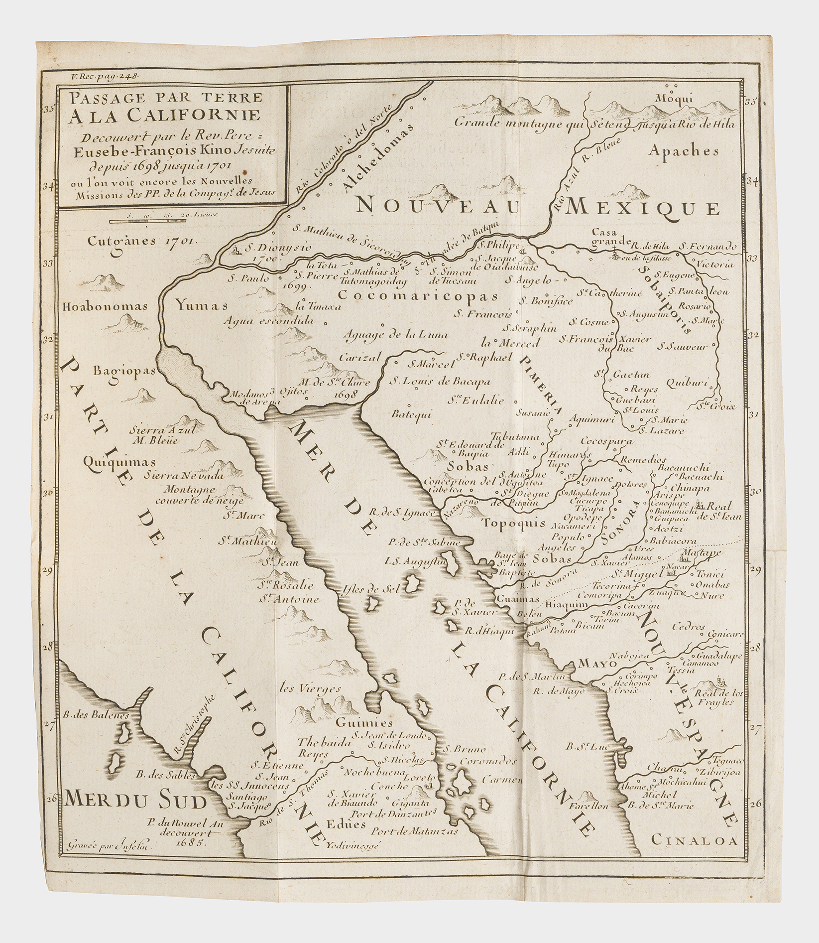
Each letter is preceded by a preface by the French Jesuit fathers. These prefaces are not reproduced in the other editions. Volume V contains Father François Mari Picolo’s very important letter on California, illustrated by a map drawn by Kino with details of California, the Gulf of California, and New Mexico with locations of some Indian tribes (Apaches, Alchedomas, Quiquimas, Yumas, Cocmaricopas, and others).
“The map is the famous Kino map of California, which appeared for the first time in this book. The map is remarkably accurate, and remained the best map of much of the area until the twentieth century” (Streeter).
There were many authors of the letters published, some of whom are listed below: for China, Fathers Contancin, Premare, Parennin, Gaubil, d’Entrecolles, Amiot and Cibot; for the East Indies, Fathers Bouchet, Tachard, Pons, Martin and de Bourzes; for the Americas, Fathers Rasles, Marest, du Poisson, Le Petit, Fauque, Lombard and Chômé; for the Levant, Fathers Siccard, Souciet, Chabert and Fromage.
“The Lettres are the most valuable 18th-century source on Jesuit activities in frontier regions throughout the world” (Hill).
Some edifying letters were sent from India, where a major mission had developed. As in China, a quarrel over rites had taken hold of the missionaries, to their detriment. “A quarrel over Malabar rites developed in the East Indies, over a question of cultural adaptation. Whereas in China they resembled mandarins, in India the Jesuits presented themselves as ‘Saniassi Brahmins’ from the North. They had to abide by the laws of the castes and adapted the religious ceremonies somewhat to Indian society. Their attitude led to protests, complicated by diplomatic difficulties with the Portuguese in India. Less resounding than the Chinese affair, this quarrel raged at the beginning of the seventeenth century, and resurfaced in 1703 with the mandate of Father Mailla de Tournon, legate of the Holy See; but there the local clergy was to calm the conflict” (see : Dictionnaire des journaux 1600-1789).
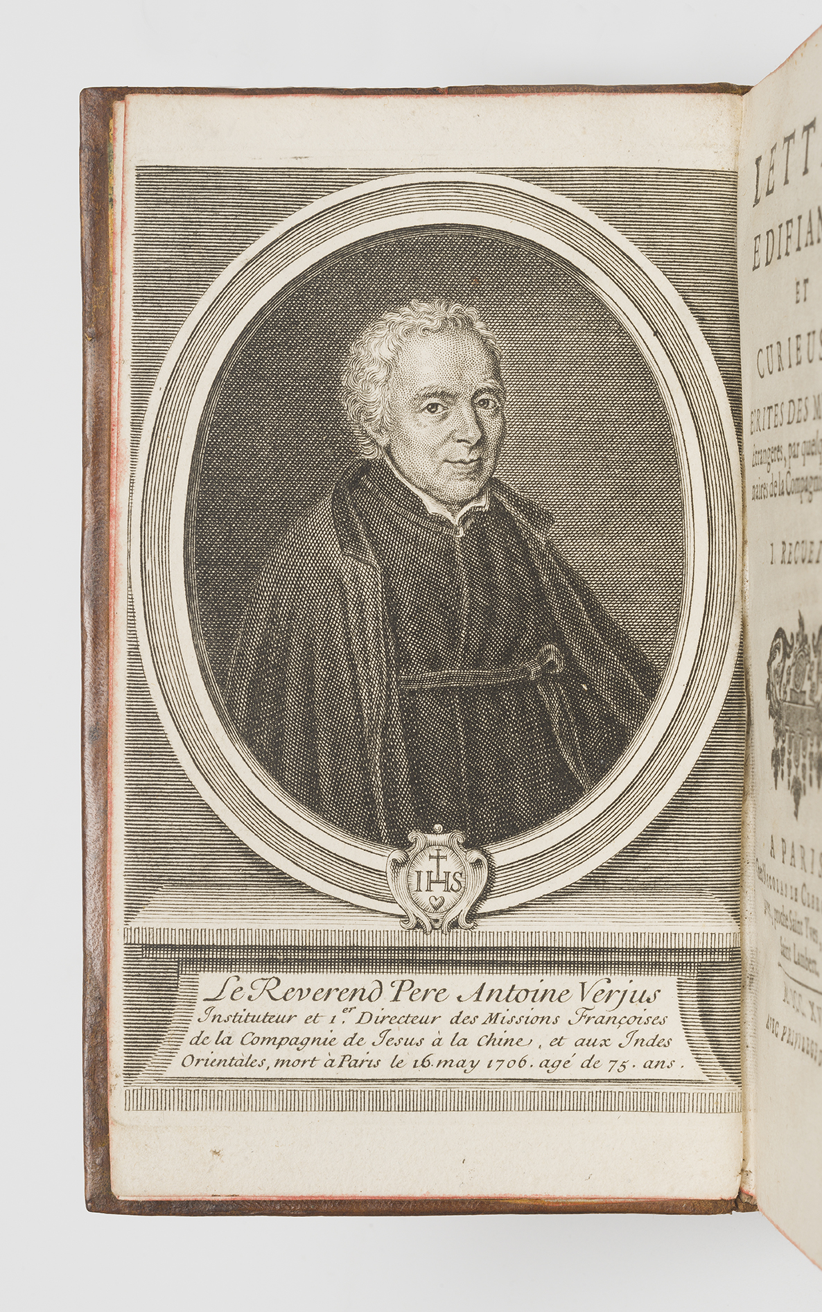
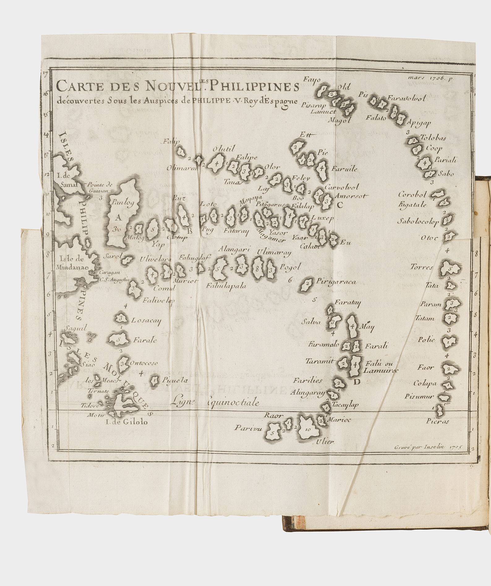
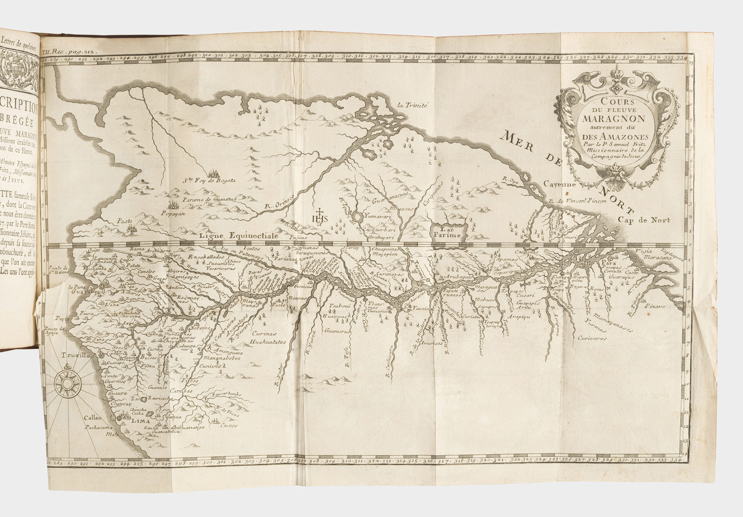
The iconography consists of an engraved portrait of Father Verjus (bound as a frontispiece) and 38 plates (maps, views and natural history), including the famous map of California, a large map (2 parts) of Tong King, a map of the Philippines and the Mariana Islands, two maps of Peru, the Amazon River, Formosa, India, etc. A large fold-out plate (volume XXIV) shows the beheading of four Jesuit fathers, notably Barthélémy Alvarez, Emmanuel de Abreu, Jean Gaspard Cratz, and Vincent da Cunha at Tong King on 12 January 1737. Another (volume XII) illustrates Catherine Tekah Koïta “Iroquois woman who died in the odour of sanctity in Canada”.
A very good copy, despite minor ocadional worming: beginning of volumes V, VII, XIV, XVI (notably in the last 3 quires), XVII slightly waterstained.
Copies complete with all volumes, the portrait and all 38 engravings are extremely rare. Lowendahl (who was missing a map in volume 27) mentions 2 maps for volume 8 (we have one), 2 maps for volume 11 (we have one). The digitised copies of volumes 8 and 11 in the Bayerische Staatsbibliothek are like ours (each illustrated with a single map). The only complete copy recently offered for sale contained the same number of plates as here (portrait and 38 plates and maps in total). Another (Duc d’Aumont copy, auctioned in 2020) contained only the portrait and 36 plates. The classic bibliographies (de Backer and Cordier) do not give a detailed collation and do not list any plates, maps or portraits.
Detailed collation on request
Detailed collation : 34 parts in 32 volumes, 12mo (160 x 90 mm). I-II (Le Clerc, 1717) : portrait frontispiece, 12 nn.ll., 136 pp., 4 nn.ll., 4 nn.ll., 194 pp., 12 nn.ll.. III-IV (Le Mercier, 1713) : title, X, 224pp., 2 nn.ll., XIX, 195 pp. V (Le Clerc, 1724) : 16 nn.ll., 287 pp., 2 nn.ll. (privilege), 1 engraved folding map (trail to California) ; VI (Le Clerc, 1723) : LXIV, 2 nn.ll., 250 pp., 3 nn.ll. (privilege), 1 engraved folding map (New Philippines) ; VII (Le Clerc, 1707) : 14 nn.ll., 366 pp., 2 nn.ll. (index), 2 engraved foldin maps (Terre de Feu, détroits de Magellan et de Le Maire ; Mer du Sud) ; VIII (Le Clerc, 1708) : 132, 343 pp., 3 nn.ll., 1 engraved folding map (Nangasaki); IX (Le Clerc, 1730) : XXIV, 431 pp., 6 nn.ll. (final blank); X (Le Clerc, 1732) 16 nn.ll., 439 pp., 4 nn.ll., 2 engraved folding plates (chinese symbols ; Ginseng plant) ; XI (Le Clerc, 1715) : 12 nn.ll., 428 pp., 3 nn.ll., 1 engraved folding map (Philippines & Mariane Islands) ; XII (Le Mercier & Boudet, 1741) : title, XXVIII, 447 pp., 1 nn.l. (approbation), 2 engraved folding maps (Mission des Moxes dans le Pérou ; cours du fleuve Maragnon), 5 engraved plates (Missionnaire aux Indes ; Rang Mouttou, fils d’un roi de Maduré ; Brame premier ministre de Maduré ; Catherine Tekah Koïta Iroquoise morte en odeur de sainteté dans le Canada ; plan de la ville et de la rivière Ganjam); XIII (Le Mercier, 1718): XXIII, 436 pp., 4 nn.ll., (index and privilege); XIV (Le Clerc, 1720) : XXVII pp., 1 nn.l. (errata & privilege), 499 pp., 4 nn.ll. (index & privilege), 3 engraved folding maps (carte des îles Ponghou ; carte de ce qui appartient à l’empereur de la Chine… île Formose; plan du fort de Zélande à Formose); XV (Le Clerc, 1722) : XL, 418 pp., 5 nn.ll., (index & privilege), 1 engraved folding map (carte des mission des pp. Jésuites dans le Maduré); XVI (Le Clerc, 1724) : XLIV (pp. 41-44 misbound at the beginning) 411 pp., 6 nn.ll. (index & privilege), 1 engraved folding map /plan gravées dépliante (plan de l’île d’Orléans), 3 engraved folding plates (vue ile de Bourbon ; lézard et écureuil volants ; poisson cornu), 4 single plates (depicting a variety of crosses); XVII (Le Clerc, 1726) : XXXIV pp., 1 nn.l. (approbation), 446 pp., 7 nn.ll. (index & privilege); XVIII (Le Clerc, 1728) : XLII pp., 3 nn.ll., (approbation), 463 pp., 6 nn.ll. (index), 1 engraved folding map (Nouvelle carte des îles Carolines); XIX (Le Clerc, 1729) : XXVIII, 506 pp., 7 nn.ll., (index & approbation); XX (Le Clerc, 1731) : XLVIII, 449 pp., 8 nn.ll., (index & privilege); XXI (Le Clerc, 1734): XLI, 486 pp., 7 nn.ll., (index & privilege), 1 engraved folding map (le Paraguay); XXII (Le Clerc, 1736): L pp., 1 nn.l. (approbation), 480 pp., 6 nn.ll. (index & privilege); XXIII (Le Clerc, 1738): XXVIII, 519 pp., 8 nn.ll. (index & privilege), 1engraved folding map (Nouvelle carte d’une grande partie de la presqu’île des Indes en deçà du Gange); XXIV (Le Clerc, 1739) : XXVIII pp., 4 nn.ll., (privilege), 444 pp., 6 nn.ll., (index), 1 engraved folding plate (quatre missionnaires jésuites… qui ont eu la tête tranchée); XXV (Le Mercier & Boudet, 1741): XXXII pp., 4 nn.ll. (approbation & privilege), 486 pp., 1 nn.l.; XXVI (Le Mercier, 1743) : title, XXXI pp., 1 nn.l. (approbation), 458 pp., 1 engraved folding plate (mollusque pétrifié); XXVII (frères Guérin, 1749) : XLIII pp., 2 nn.ll. (privilege), 480 pp., 1 engraved folding map (carte des envirions du cap François [St Domingue]), 1 engraved folding plate (Chayaver plant); XXVIII (H.L. Guérin & L.F. Delatour, 1758) : LXXXVIII, 451 pp., 1 engraved folding map (carte des îles Lieou-Kieou); XXIX (Ruault, 1773) : XXIV, 379 pp. XXX (Ruault, 1773): 2 nn.ll., 410 pp., 1 nn.l. (privilege); XXXI (de Hansy, 1774) : XVI, 390 pp., 1 nn.l. (privilege), 2 engraved folding maps (2 mapd of Tong-King), 1 woodcut folding plate with typographical (column in the synagogue at Cai-Fong-Fou); XXXII (de Hansy, 1774) : XII, 394 pp. 1 nn.l.(privilege); XXXIII (Charles-Pierre Berton, 1776): XII, 443 pp.; XXXIV (Charles-Pierre Berton, 1776): XXIV, 402 pp.
Monday to Saturday
10am – 1pm and 2:30pm – 7pm
(6pm Monday and Saturday)
© 2023 All rights reserved.