Tooley, Maps and Mapmakers (1984); Frangenberg, Chorographies of Florence. The Use of City Views and City Plans in the Sixteenth Century, in: Imago Mundi, 46, 41-64.
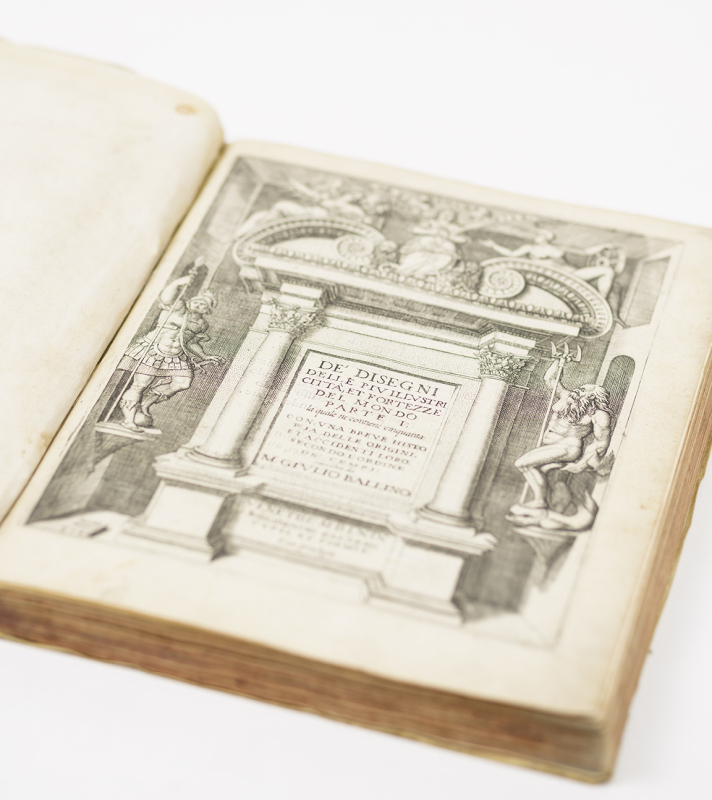
Rare first and only edition of the first city atlas produced in Italy, inaugurating a significant movement in Italian chorography which gathered steam during the 1570s and 80s.
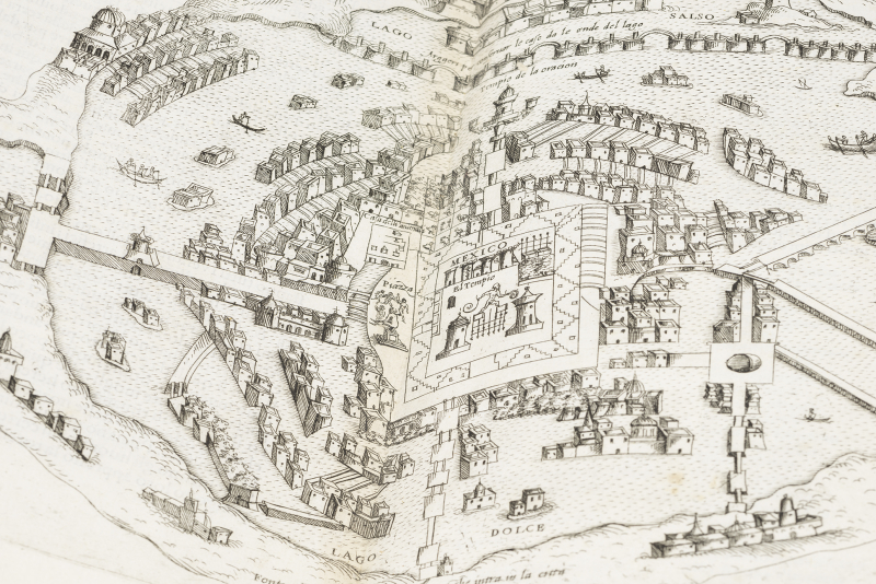
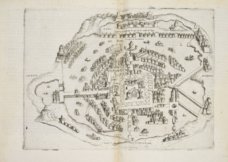
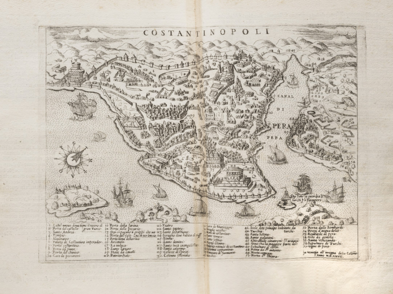
Depicting views ranging from Venice to Tenochtitlan, Mexico, the work appeared during the Golden Age of Venetian cartography and promises the reader the most up-to-date catalogue of city plans and views. Ballino’s work was evidently produced to feed the demand for comprehensive collections of maps during this period, as noted by Tooley (pp 20-21). As was customary in books which might contain valuable military knowledge, Ballino has populated his maps with the occasional human figure – a practice stated by many cartographers of the period to ensure that they could not be used by Muslim invaders for reasons of idolatry. Ballino’s atlas is in fact notably militaristic, emphasizing fortifications and historic military events in many of his maps – Hale’s Renaissance War Studies cites the Disegni delle piu illustri Citta as “the first topographical work aimed at an audience primarily interested in war” (p 456). Nevertheless many of his views also imply a concerted interest in the architecture and urban design of these cities. Rome is depicted in four different views, including its antique appearance, its modern reincarnation, and a bird’s eye view of a particular ‘borgo di Roma’. Other cities appear as battlefields, with buildings of significant strategic interest noted in the legend. Several non-European city plans are of significance, including the Mexican capital of Tenochtitlan, replete with boatmen and Aztec-style flat-roofed houses. The quality of the engravings, many signed by Domenico Zenoi, is very high, while almost every map bears a caption attesting to its credibility: “The true design of the plan of Milan as it is truly found today”, etc.
Several commentators have remarked upon Ballino’s use of legends; Thomas Frangenberg calling his map of Florence the “first to provide a key”, while Alfred Franklin was similarly impressed with the amount of information Ballino is able to depict in his map of Paris, far surpassing Münster’s efforts. Ballino’s legends not infrequently run to 30 or 40 sites of interest, while his map of Messina in the present work depicts no less than 167 numbered features of the Sicilian town.
“Ballino’s key allows the user of his chorography of Florence to locate a large number of monuments, and not only the most conspicuous ones, within the urban context” (Frangenberg). Ballino’s work was the first Italian atlas of its kind, preceded among city atlases only by Antoine Du Pinet’s Plants, Pourtraitz et Descriptions de Plusieurs Villes (Lyon, 1564), which drew most of its illustrations from the Cosmographies of Guillaume Guéroult and Sebastian Münster. There appear to be issues of the present work, as yet undescribed.
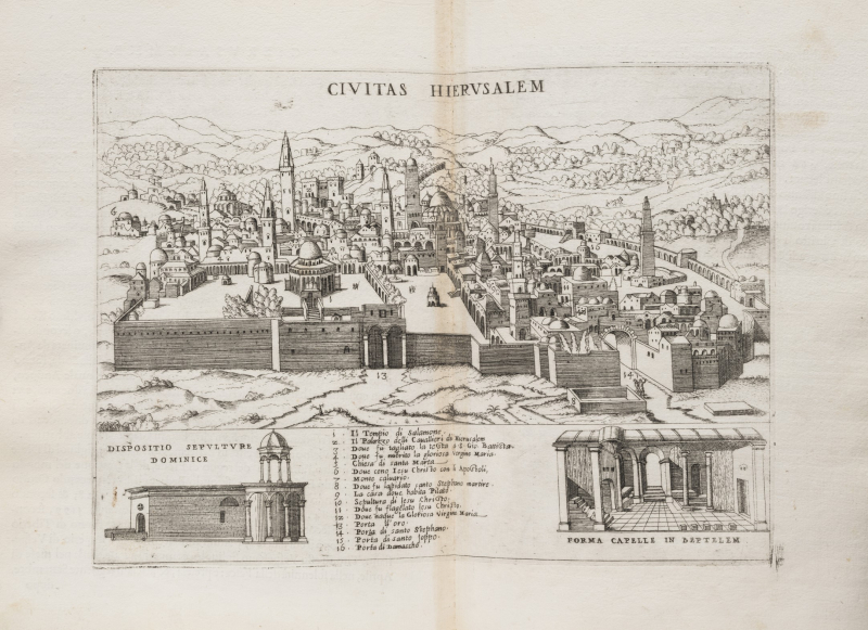
The 52 engravings depict: Transsylvania, Venice, Fano, Mirandola, Florence, Siena, Rome (4), Ostia, Nettuno, Civitella, Vicovarro, Naples, Messina, Genova, Parma, Piacenza, Milan, Crescentino, Paris, Perpignan, Metz, Tionville, Calais, Guînes (printed upside-down), Antverp, Gravelines, Augsburg, Francfurt, Geneva, Gotha, Wittenberg, Vienna, Agria (Hungaria), Giavarino (Hungaria), Comar (Austria), Gyula, Tocai, Sziget, Saaca, Constantinople, siege at Tokay (signed by Forlani in the copper plate), Jerusalem, Tiberiade, Malta (one view of the island, the other showing the fortifications), Tripolis, Zerbe (Africa), the Rock of Vélez de Gomera, and Tenochtitlan.
Very good copy, small occasional marginal waterstain, view of Siena with small ink stains.